H6. Subsurface Movement of Water
Instructional Objectives
The learner will be able to learn after this lesson:
-
The modes of water movement below
-
How underground water is broken and stored in the soil
-
What is the definition of water table and how does it relate to saturated and unsaturated ground?
-
measurement of soil pressure in both dry and wet conditions
-
The explanation for how water moves in an unsaturated
-
The rationale for water movement in the saturated zone, often known as the ground
-
Flow and equipotential
-
Aquifers and confining
-
The movement of the ground water in restricted and unconfined spaces, qualitatively
-
the definitions of stored water and the amount that can be taken out of an aquifer.
The hydrologic cycle is a continuous process of water vapor evaporation, cloud formation, and condensing into rain. Surface water is a direct source for water resources engineering, but groundwater reserves are often untapped. Excessive withdrawal of groundwater in India and other regions has led to problems and irreversible changes in subsurface water quality and quantity, potentially affecting future generations. Water resources engineers must be aware of these consequences to ensure sustainable water management.
This lecture explores the physics of water infiltrating soil, separating subsurface water movement from surface flow due to the varying scales of these two types of flows, as illustrated in Figure 1.
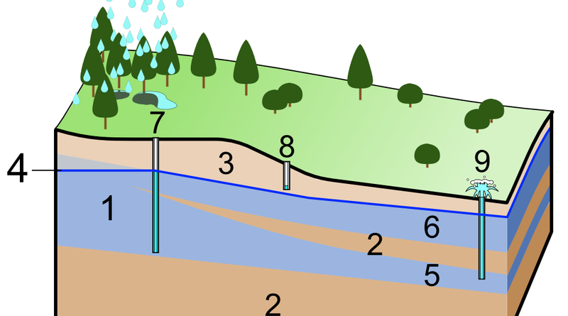
1 Subsurface water and the soil – rock profile
Figures 2 and 3 depict the interactions between underground soil-rock profiles and subsurface water, categorized as confined and unconfined groundwater reserves.
Water exists in soil pores and rock fissures up to solid rock depth, partially filled above the water table, and completely saturated below it.
The upper layers of the soil rock system reveal that moisture content separates unsaturated and saturated portions, with the remaining unsaturated portion being the groundwater-storing portion.
Even in the driest climates, the unsaturated zone’s saturation level remains non-zero due to surface tension causing water to adhere to soil particles.
The following definitions pertain to subsurface water:
- Water buried in the top layers of soil, from the surface to the depth at which plant roots extend, is known as soil water.
- Vadose water is that which is underground and is kept between the capillary fringe and the soil water zone. It establishes a connection between groundwater leaking through the ground surface and descending to the saturated layer of groundwater.
- Water that has risen from a saturated groundwater area as a result of capillary action Naturally, there would be less pressure than atmospheric here.
- Water that is completely saturated is referred to as ground water. Water would be under greater air pressure in this area.
- The imaginary surface of the ground below which the gaps in the soil or permeable rock are entirely filled with water is known as the water table. The pore water pressure below this hypothetical surface is atmospheric. According to the hydrostatic law, the pressure rises as one descends from the water table. Water adhering to the surface of the solids by surface is only partially saturated in the soil gaps and porous rock above the water table. As a result, the pressure is sub-atmospheric.
2 Water pressure in unsaturated zone
Ground water flow refers to the movement of water in both saturated and unsaturated soil or fractured bedrock, crucial for extraction and preservation.
- The moisture for vegetation comes from the water in the unsaturated zone (soil water).
- This zone serves as a conduit for surface and subsurface hydrologic processes because rainwater percolates through it to replenish the soil.
- The unsaturated zone’s water evaporation or transpiration losses, primarily from the soil water zone, recharge the atmosphere.
Infiltration, a crucial hydrologic modeling process, occurs in the unsaturated zone, making understanding unsaturated zone water movement more effective.
The hydraulic head at a point is defined by the pressure head (Ψ), which is zero in the unsaturated zone and positive in the saturated zone.
h = z +y
(1)
The equation z represents the potential head due to gravity, indicating that water flows from higher hydraulic head to lower hydraulic head in the flow mechanics.
A tensiometer measures negative pressure head in unsaturated zones using a porous ceramic cup connected to a manometer, while the hydrostatic pressure head formula determines positive pressure head below water table.
3 Movement of water in unsaturated zone
The metaphorical term “thirsty” refers to the negative pressure head in the soil’s unsaturated zone. The dirt here does not have all of its pores filled. Water is therefore “lapped up” by the soil matrix as soon as it is applied to the soil surface. Water wouldn’t flow over the surface of the ground as surface runoff unless more water was applied than it could “drink”. This capacity of the soil to absorb water in the unsaturated region truly depends on the volumetric water content, which is represented as follows:
q = Vw
V
Where Vw is the volume of water and V is the unit volume of soil or rock.
Gravity causes water absorbed at an unsaturated soil surface to travel downward through pores filled with water. As water content rises, more pores fill, and the water goes downward more quickly.
Water flow inside soil or permeable bed rock is measured by hydraulic conductivity (K). It depends on the amount of moisture in the soil’s unsaturated region, with K rising as does. Figure 5 shows how the relationship is related.
In reality, as illustrated in Figure 6, the moisture potential () is also a function of.
Experimental research is used to determine the link between volumetric water content and unsaturated hydraulic conductivity. a jar containing a soil sample. The amount of water is maintained constant, and the speed at which the water percolates through the soil is gauged. This is repeated for various values, or various saturation levels. Unsaturated flow, by its very nature, entails numerous variations in volumetric moisture content as waves of infiltration pass, hence it must be advised that both K and.
Figure 7 is a typical example of how a continuous stream of water penetrating from the ground into an unsaturated soil.
The distribution of water content with depth may resemble Figure 8 if the source of the water has now been shut off.
4 Movement of water in saturated zone
Water infiltrating unsaturated soil layers and moving vertically reaches the saturated zone, raising the water table and referred to as the’recharge’ of ground water.
Figure 9 shows a small gradient of water table towards the river before infiltration. However, after recharge due to infiltrating water, the gradient increases, affecting ground water flow. Equipped with hydraulic head lines and flow lines, the gradient affects ground water flow within the saturated soil zone.
Groundwater movement varies with the material it flows through, as it moves through voids. Hydraulic conductivity, denoted by ‘K’, indicates the ease with which water can flow through a porous medium. Homogeneous porous materials have consistent hydraulic conductivity in any direction. However, soil layers and fractured bed rock in nature can cause variations in hydraulic conductivity, making natural flows more preferential in certain directions. This heterogeneous conducting media is anisotropic.
5 Examples of ground water flow
This qualitative discussion discusses ground water flow, a three-dimensional phenomenon, and its interaction with surface water bodies like lakes and rivers. It uses examples to illustrate the relationship between flow and porous medium geology.
- Example of a gaining lake and
Figure 11 depicts an illustration of a lake that is situated on a hill and is supplied with water by the surrounding hill masses. It also depicts a river that is receiving water that flows down in a valley.
- Example of a partially losing lake, a disconnected losing lake, and a gaining
This example somewhat adjusts the circumstances of example 1 as seen in Figure 12.
- Example of flow through a heterogeneous media, case
This example (Figure 13) shows the potential flow through a low hydraulic conductivity subsoil material sandwiched between two materials with relatively higher hydraulic conductivities.
- Example of flow through a heterogeneous media, case
This situation (Figure 14) is directly in opposition to that of Example 3. A subsoil material with a high hydraulic conductivity is being flowed through in this instance, wedged between two materials with comparatively modest hydraulic conductivities.
6 Water table contours and regional flow
We can analyze the movement of ground water on a regional scale for a region, such as a watershed, if we draw (on a horizontal plane) contours of equal hydraulic head. The concept is illustrated in Figure 15 using the assumption that the area has homogeneous porous media with varied degrees of hydraulic conductivity (which is only normal for a real situation).
7 Aquifer properties and ground water flow
Porosity
Ground water is stored in soil pores or rock fractures, with porosity determining the percentage of void material in earth materials.
n = 100vv
v
(2)
Where n is the porosity, expressed as percentage; vv is the volume of void space in a unit volume of earth material; and v is the unit volume of earth material, including both voids and solid.
Specific Yield
Porosity measures water bearing capacity in formations, but not all water can be drained due to molecular and surface tension forces. Gravity and surface tension balance the water’s stress, causing some water to pull away and drip downward. The Specific Yield (Sy) is the ratio of water draining from saturated soil or rock to the total aquifer volume.
Two porosity-equivalent samples have similar average grain sizes, but the finer sample has a larger surface area, allowing more water to be held as hygroscopic moisture.
Specific Retention Sr is the volume of water retained by molecular and surface tension forces against gravity, corresponding to Field Capacity and the saturated sample volume.
Consequently, the following relationship is valid:
n = S y + Sr
(3)
Specific storage (ss)
The amount of water per unit volume of a saturated formation that is stored or released from storage as a result of the mineral skeleton’s compressibility and the pore water per unit change in potentiometric head is known as specific storage (ss), also known as the elastic storage coefficient. The phrase “Specific Storage” provides information.
Ss = g (a + nb )
(4)
where g is the unit weight of water, a is the compressibility of the aquifer skeleton; n is the porosity; b .is the compressibility of water.
Specific storage has the dimensions of length-1
The storativity (S) of a confined aquifer is the product of the specific storage (Ss) and the aquifer thickness (b).
S = bSs
(5)
The compressibility of the mineral skeleton and pore water are responsible for all of the released water. The entire depth of the aquifer is where the water is found.
With variations in the amount of water in storage, the saturation level in an unconfined aquifer rises or falls. Water drains from the pore spaces when the water level drops. The specific yield (Sy) of the aquifer is to blame for this storage or release. Therefore, the formula can be used to determine the storativity for an unconfined aquifer.
S = S y + hSs
Where h is the thickness of the saturated zone.
Since the value of Sy is several orders of magnitude greater than hSs for an unconfined aquifer, the storativity is usually taken to be equal to the specific yield.
8 Aquifers and confining layers
Natural geologic formations have varying hydraulic conductivities due to weathering, fracturing, and solution effects from parent bed rock. Soil grain size and fractured rock size significantly affect ground water flow, influencing hydrogeology terms.
- Aquifer: This geologic formation has the capacity to store and transmit water at rates quick enough to adequately hydrate wells.
- Confining layers: This geologic formation exhibits relatively low hydraulic conductivity. The subsequent divisions of confining layers are as follows:
- Aquifuge:a layer that is completely impermeable and won’t allow any
- Aquitard: The phrase “leaky aquifer” refers to a layer with poor permeability that can hold ground water and transmit slowly from one aquifer to another.
- Aquiclude: a low permeability component that forms the upper or lower border of a ground water flow notwithstanding its location
Unconfined aquifers extend below land surface, while confined or artesian aquifers are located below the surface, overlain by a confining layer, with pressured water.